NIMBO Terrain (Terrarium)
The Nimbo Terrarium layer provides a global Digital Elevation Model (DEM) service, including bathymetry (ocean depth). It delivers raster heightmaps encoded in RGBA tiles, following the historic format initiated by Mapzen.
This service is a high-performance replacement for legacy Mapzen endpoints, designed for 3D rendering engines, broadcast pipelines, and GIS applications requiring the specific Terrarium encoding standard.
Technical Specifications
Section titled “Technical Specifications”Encoding Format
Section titled “Encoding Format”The elevation values are encoded into the Red, Green, and Blue channels of the image tile. This technique allows 3D software (like Blender, Unity, or Three.js) to read elevation data from a standard image texture.
| Feature | Details |
|---|---|
| Service URL | https://prod-data.nimbo.earth/tiles/terrarium/{z}/{x}/{y}?kermap_token=<YOUR_TOKEN> |
| Format | PNG |
| Zoom Levels | 0 to 13 |
| Coordinate System | Web Mercator (EPSG:3857) |
| Coverage | Global Land (85°N to 85°S) |
| Tile Size | 256x256 px |
Decoding Formula
Section titled “Decoding Formula”To parse the altitude in meters from a pixel, apply the specific Mapzen / Terrarium decoding equation:
elevation = (red * 256 + green + blue / 256) - 32768- Red (R) & Green (G): Encode the integer part of the elevation.
- Blue (B): Encodes the fractional precision.
- Offset (-32768): This significant negative offset allows the format to represent the deepest parts of the ocean (e.g., the Mariana Trench) without using negative pixel values.
Zoom Levels & Resolution
Section titled “Zoom Levels & Resolution”Nimbo provides native terrain tiles up to Zoom Level 13.
While the legacy Mapzen dataset technically offered tiles up to z15, Nimbo’s optimized processing focuses on high-quality data aggregation up to z13 (approx. 19 meters/pixel at the equator).
Data Provenance & Sources
Section titled “Data Provenance & Sources”Originally hosted on AWS Public Datasets (s3.amazonaws.com/elevation-tiles-prod/terrarium/), the Mapzen service was discontinued in 2018.
The Nimbo Terrarium feed is an exact replica of the historic Mapzen elevation dataset.
Nimbo hosts a static copy of the original archives to guarantee absolute backward compatibility for legacy systems and shaders built specifically for this dataset.
As defined in the original Mapzen specifications, this composite dataset includes:
- Global Landmass (30m): primarily based on NASADEM and SRTM v3 (Shuttle Radar Topography Mission) provided by NASA, ensuring consistent mid-latitude coverage.
- High-Resolution Regional Data: We integrate higher precision Local DEMs where available, such as USGS NED/3DEP (USA), CDEM (Canada), and EU-DEM (Europe).
- Bathymetry & Oceans: Unlike many terrain services that clip at sea level, Terrarium includes seafloor topography derived from ETOPO1 (NOAA) and GEBCO, making it ideal for marine visualization.
- Polar Regions: Enhanced coverage for Arctic and Antarctic regions using ArcticDEM and REMA datasets.
Data resolution per location
Section titled “Data resolution per location”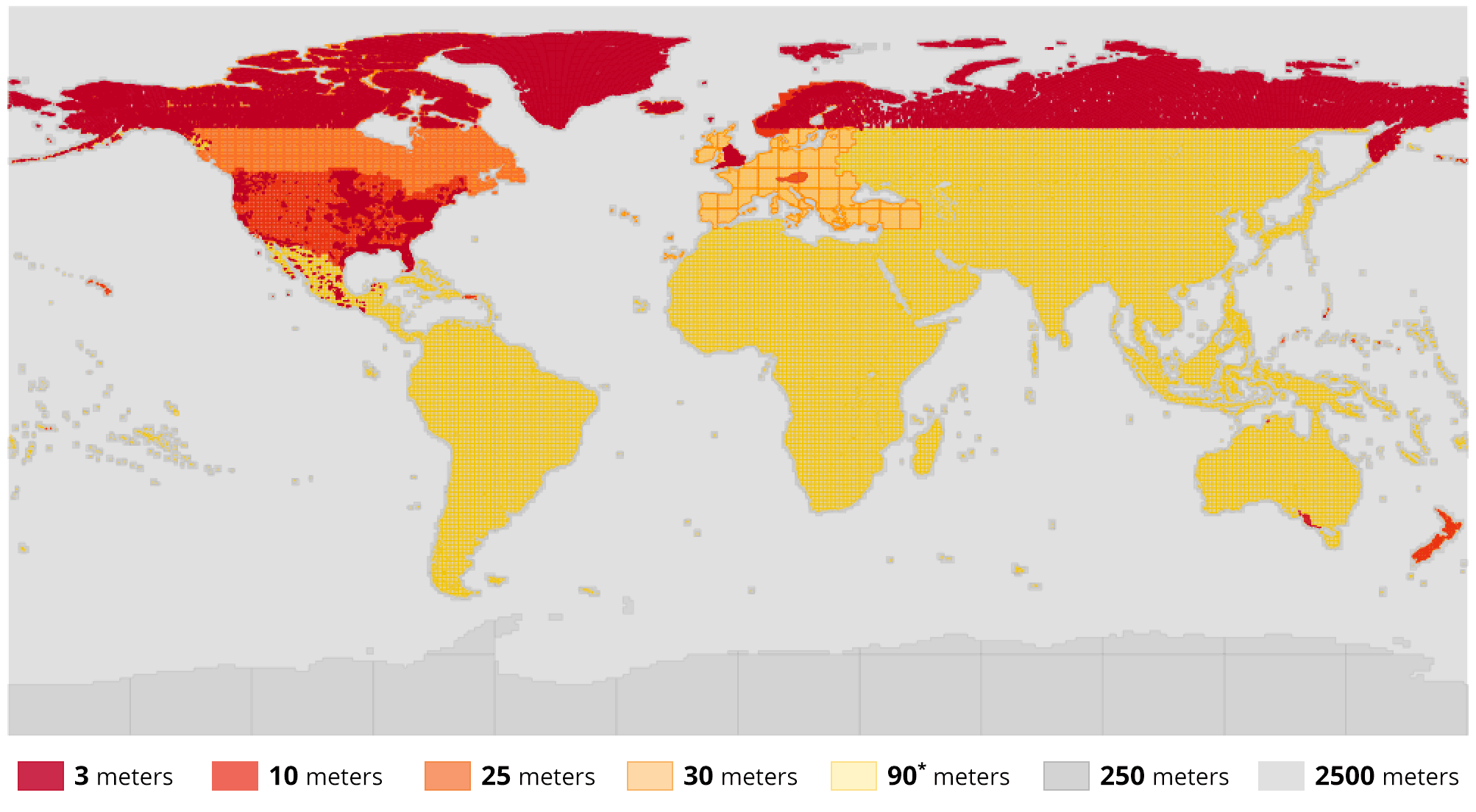
Data sources by zoom level
Section titled “Data sources by zoom level”| zoom | ocean | land | Ground resolution at 0° | Ground resolution at 45° | Ground resolution at 60° |
|---|---|---|---|---|---|
| 0 | ETOPO1 | ETOPO1 | 156543.0 | 110692.6 | 78271.5 |
| 1 | ETOPO1 | ETOPO1 | 78271.5 | 55346.3 | 39135.8 |
| 2 | ETOPO1 | ETOPO1 | 39135.8 | 27673.2 | 19567.9 |
| 3 | ETOPO1 | ETOPO1 | 19567.9 | 13836.6 | 9783.9 |
| 4 | ETOPO1 | GMTED | 9783.9 | 6918.3 | 4892.0 |
| 5 | ETOPO1 | GMTED | 4892.0 | 3459.1 | 2446.0 |
| 6 | ETOPO1 | GMTED | 2446.0 | 1729.6 | 1223.0 |
| 7 | ETOPO1 | SRTM, NRCAN in Canada, with GMTED in high latitudes above 60° | 1223.0 | 864.8 | 611.5 |
| 8 | ETOPO1 | SRTM, NRCAN in Canada, with GMTED in high latitudes above 60° | 611.5 | 432.4 | 305.7 |
| 9 | ETOPO1 | SRTM, NRCAN in Canada, EUDEM in Europe, with GMTED in high latitudes above 60° | 305.7 | 216.2 | 152.9 |
| 10 | ETOPO1, NED Topobathy in California | SRTM, NED/3DEP, ArcticDEM, LINZ, Kartverket, etc. | 152.9 | 108.1 | 76.4 |
| 11 | ETOPO1, NED Topobathy in California | SRTM, NED/3DEP, ArcticDEM, LINZ, Kartverket, etc. | 76.4 | 54.0 | 38.2 |
| 12 | ETOPO1, NED Topobathy in California | SRTM, NED/3DEP, ArcticDEM, LINZ, Kartverket, etc. | 38.2 | 27.0 | 19.1 |
| 13 | ETOPO1, NED Topobathy in California | SRTM, NED/3DEP, ArcticDEM, LINZ, Kartverket, etc. | 19.1 | 13.5 | 9.6 |
Integration examples
Section titled “Integration examples”MapLibre GL JS
Section titled “MapLibre GL JS”Terrarium DEM encoding is not the default encoding expected by MapLibre GL JS.
When defining your source, you must explicitly set encoding: "terrarium".
Failing to do so will result in incorrect elevation values.
In addition, set maxzoom to 13. This allows the rendering engine to oversample the DEM tiles when users zoom further (z14+), ensuring smooth terrain rendering.
"sources": { "nimbo-terrain": { "type": "raster-dem", "tiles": [ "https://prod-data.nimbo.earth/tiles/terrarium/{z}/{x}/{y}.png?kermap_token=<YOUR_TOKEN>" ], "tileSize": 256, "encoding": "terrarium", "maxzoom": 13 }}