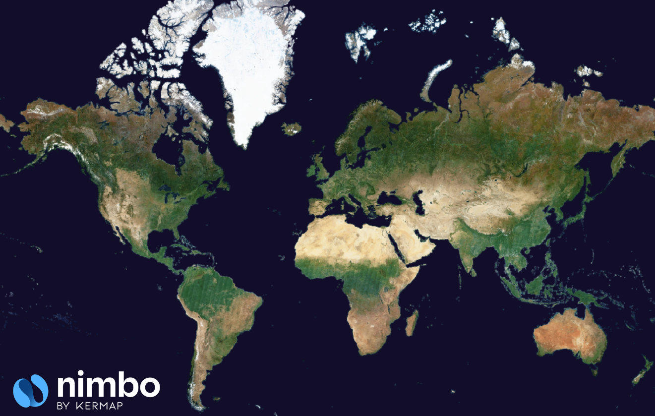
NIMBO (10m) Basemaps
NIMBO’s 10 m Basemaps are global, cloud-free mosaics generated every month from Sentinel-2 satellite imagery. They provide a harmonized, radiometrically stable view of the Earth at 10-meter resolution, making it one of the freshest, most reliable global satellite basemaps available for professional GIS, environmental monitoring, agricultural analytics, and Earth observation workflows.
Updated each month and delivered through high-performance TMS/WMTS endpoints, NIMBO Basemaps are designed to support both large-scale visualization and advanced geospatial analysis.
Technical Specifications
Section titled “Technical Specifications”| Feature | Details |
|---|---|
| Service URL | https://prod-data.nimbo.earth/mapcache/tms/1.0.0/{year}_{month}_{layer_name}@kermap/{z}/{x}/{y}.png?kermap_token=[YOUR_TOKEN] |
| Format | PNG (RGB) |
| Zoom Levels | 0 to 18 |
| Coordinate System | Web Mercator (EPSG:3857) |
| Coverage | Global Land (85°N to 85°S) |
| Tile Size | 256x256 px |
Parameters:
year: Four-digit year (e.g.2024)month: Month number (1–12)layer_name: Basemap identifier. Use1for RGB, Natural color composite. Get list of identifiers here.z,x,y: Standard XYZ tile coordinates.kermap_token: Your API authentication token.
Available spectral and analytical layers
Section titled “Available spectral and analytical layers”NIMBO’s 10 m Basemaps include a complete set of spectral and analytical layers derived from Sentinel-2 and Sentinel-1. These layers are delivered through simple, predictable naming conventions, making it extremely easy to retrieve the correct feed for any application. Each month and each layer follow the same pattern: a date, a layer code, and a consistent tile endpoint. This ensures seamless integration in GIS tools, web-mapping libraries, dashboards, or automated processing pipelines.
| Layer | Description | Identifier | Example |
|---|---|---|---|
| RGB | Natural color composite | 1 | …{year}_{month}_1 |
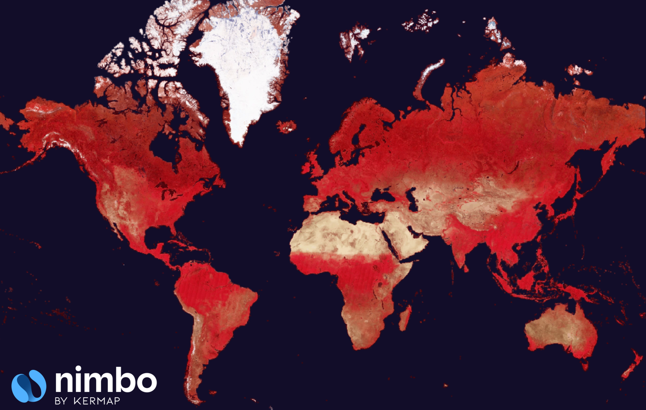
| NIR | Near-infrared composite | 2 | …{year}_{month}_2 |
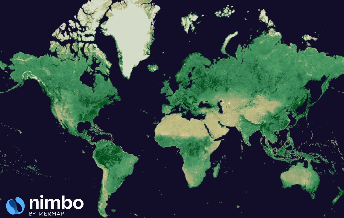
| NDVI | Vegetation index | 3 | …{year}_{month}_3 |
| RADAR | Sentinel-1 backscatter mosaic | 4 | …{year}_{month}_4 |
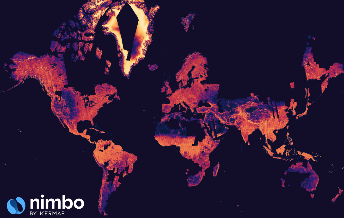
| Traceability (10m) | Pixel age relative to month | 6 | …{year}_{month}_6 |
Because all layer identifiers follow the same structure every month, users do not need to guess or search for the right service. Switching from RGB to NDVI or from NIR to LAI simply means changing a single number in the URL. This consistency makes NIMBO particularly easy to script, automate, and integrate into existing monitoring systems without additional configuration or metadata lookup.
Data availability timeline
Section titled “Data availability timeline”The geographic coverage of Nimbo Basemaps has expanded over time, evolving from a regional validation phase to a fully global service.
Since February 2023, Nimbo has achieved Full Global Coverage, delivering cloud-free basemaps for all continents and major islands every month.
| Period | Coverage Area | Status |
|---|---|---|
| Feb 2023 – Present | Global | Full Coverage (All continents) |
| Mar 2022 – Jan 2023 | USA + Europe + MENA* | Extended Coverage |
| Oct 2019 – Feb 2022 | Europe + MENA* | Historical Archive |
*MENA: Middle East, North Africa, and Western Russia.
Historical Back-processing & Custom Requests
Section titled “Historical Back-processing & Custom Requests”While the standard API provides immediate access to the archives listed above, our processing pipeline is capable of regenerating global basemaps for earlier years (e.g., 2020 or 2021) upon request.
What is NIMBO basemaps (10m) ?
Section titled “What is NIMBO basemaps (10m) ?”Monthly updates and data freshness
Section titled “Monthly updates and data freshness”Every month, NIMBO processes the complete set of Sentinel-2 acquisitions and generates a single, unified mosaic. The result is released shortly before the 15th of the following month, offering one of the fastest global update cycles currently available at 10 m.
The monthly cadence is designed to balance temporal responsiveness with radiometric stability: each mosaic captures the state of the Earth as close as possible to real conditions, while avoiding the noise and artefacts that daily imagery can introduce. Because the same synthesis rules are applied every month, users can rely on a consistent time series suitable for environmental monitoring, seasonal analysis, and landscape-scale workflows.
How the monthly composites work
Section titled “How the monthly composites work”Unlike traditional mosaicking approaches that simply select the “best” pixel from available scenes, NIMBO uses a more advanced process designed to reconstruct what the Earth would look like on the 15th of the month, without any clouds. The system does not choose individual pixels; instead, it models a unified image for the mid-month date using all Sentinel-2 acquisitions collected during the period.
This modeling relies on temporal interpolation techniques that account for how each landscape evolves during the month. By combining multi-date observations through controlled weighting and radiometric interpolation, the method preserves the full color dynamics of each environment—whether agricultural areas, forests, deserts, wetlands, mountains, or dense urban regions. This ensures natural transitions and prevents the color drifts and patchwork effects seen in traditional mosaics.
Because the process recreates a synthetic yet physically consistent image, the final result behaves like a global photograph taken on the 15th, in which no clouds are present anywhere on Earth. This is one of the core strengths of the NIMBO basemap and a key reason why it remains visually stable and radiometrically coherent across continents, seasons, and land-cover types. The output is a single, cloud-free, globally uniform mosaic, ready for both visualization and quantitative analysis.
Cloud removal and quality control
Section titled “Cloud removal and quality control”NIMBO basemaps rely on their own cloud-detection algorithm, developed specifically for Sentinel-2 and trained using thousands of annotated images from all over the world. This model is based on machine learning and goes far beyond a simple binary “cloud / no cloud” classifier. Instead, it evaluates cloud transparency, detecting not only opaque clouds but also thin cirrus, semi-transparent formations, haze layers, and cloud shadows.
By quantifying cloud opacity rather than treating clouds as a binary mask, the algorithm allows the synthesis pipeline to avoid retaining pixels that contain subtle atmospheric contamination. This produces significantly cleaner and more natural mosaics, especially in areas where traditional cloud masks struggle—humid tropics, monsoon regions, equatorial forests, and mountainous zones.
Every Sentinel-2 acquisition passes through this model before entering the synthesis. Only observations meeting strict cloud-free and atmospheric-quality thresholds contribute to the mid-month reconstruction. This ensures that even in extremely cloudy regions, the NIMBO basemap remains free of artefacts and maintains consistent radiometric behaviour across scenes.
Traceability layer
Section titled “Traceability layer”The Traceability layer (10m) indicates how fresh each pixel is relative to the target month. This information is essential because, in some regions of the world, a full month of Sentinel-2 acquisitions may be completely unusable due to persistent cloud cover. When this happens, the mosaic must fall back to data from earlier months to preserve cloud-free coverage.
Regions where this situation frequently occurs include Gabon and Central Africa, the Amazon basin, India during monsoon season, and Southeast Asia. In such areas, it is common to have an entire month with no available cloud-free observations.
This layer ensures temporal transparency — you always know where the image is truly up-to-date. This helps users evaluate temporal reliability and to mask or filter outdated pixels when performing agricultural monitoring, phenological analysis, or any workflow requiring strict temporal precision. It also helps avoid misinterpretation in regions where cloud cover forces older observations to be used.
For more information about Traceability layer (10m), go here.
Comparison with other basemaps
Section titled “Comparison with other basemaps”Many organizations rely on satellite basemaps such as Google Maps, Bing or ESRI basemaps. While each solution serves a purpose, they differ greatly in terms of update frequency, temporal transparency, and performance. NIMBO’s 10 m Basemaps stand out by offering a unique combination of monthly updates, cloud-free mosaics, full temporal traceability, and high-speed tile delivery, making it particularly suitable for monitoring, analysis, and operational decision-making.
CDSE issues fixed by Nimbo
Section titled “CDSE issues fixed by Nimbo”Platforms such as Sentinel Hub and Copernicus Data Space Ecosystem (CDSE) provide access to raw Sentinel-2 scenes, but they do not deliver monthly global basemaps. Users must deal with clouds, inconsistent acquisition dates, and radiometric variations. Additionally, because the rendering is computed on the fly, tile response times can be slow, especially at high zoom levels or when processing large areas. This often leads to delays in dashboards and analytic tools, particularly when accessed by multiple users.
Fast display
Section titled “Fast display”In contrast, NIMBO delivers high-performance TMS and WMTS tiles that are optimized for extremely fast loading, even at continental scale. Our tile servers are engineered to provide immediate, near-instant display, often loading significantly faster than comparable Sentinel Hub endpoints. This responsiveness is essential for interactive platforms, large monitoring dashboards, and real-time decision tools used in agriculture, environmental management, or urban planning.
Data freshness
Section titled “Data freshness”Traditional basemaps are composed of imagery aggregated from multiple years, often blended from heterogeneous sources. Users rarely know when a specific pixel was captured, making these basemaps unsuitable for detecting change, assessing seasonal conditions, or supporting regulatory monitoring such as deforestation alerts or EUDR compliance. With no clear timestamp and no update rhythm, Google Maps is excellent for general navigation but fundamentally limited for professional Earth observation workflows.
With NIMBO, every mosaic is tied to a specific month, and every pixel includes a traceability value that indicates whether it originates from the target month or from an earlier fallback. This allows users to understand the true temporal value of the data they are analysing—something that no other major basemap provider currently offers.
Because NIMBO is updated every month, it enables precise monitoring of land cover evolution, vegetation dynamics, seasonal patterns, agricultural cycles, and slow-moving environmental change. Users are not forced to rely on multi-year basemaps with unknown acquisition dates; instead, they can work with a regular, transparent, and predictable global dataset, designed explicitly for monitoring and analysis rather than static visualization.
The best balanced imagery resource
Section titled “The best balanced imagery resource”Together, these characteristics - cloud-free modeling, monthly cadence, temporal transparency, radiometric stability, and exceptional loading performance - position NIMBO as a modern, analysis-ready alternative to traditional basemaps. It is the first global 10 m mosaic explicitly designed for change detection, operational monitoring, and EO-based decision systems, not just for static map display.
| Provider | Resolution | Update Frequency | Cloud-Free | Color Consistency | Traceability | Notes |
|---|---|---|---|---|---|---|
| ~0.5–5 m | Multi-year | No | Variable | No | Visualization-oriented, not monthly | |
| CDSE | 10 m | Daily scenes | No | Good | No | Raw scenes rendered on demand |
| MapTiler | 10–30 m | Irregular | No | Correct | No | Based on various public mosaics |
| NIMBO | 10 m | Monthly | Yes | Global & stable | Yes | Monthly cloud-free mosaic with temporal metadata |
Integration examples
Section titled “Integration examples”### TMS accesshttps://prod-data.nimbo.earth/mapcache/tms/1.0.0/{YEAR}{MONTH}{LAYER}@kermap/{z}/{x}/{-y}.png?kermap_token=<YOUR_TOKEN>### WMTS capabilitieshttps://prod-data.nimbo.earth/mapcache/wmts?kermap_token=<YOUR_TOKEN>### Example (RGB, June 2024)https://prod-data.nimbo.earth/mapcache/tms/1.0.0/2024_6_1@kermap/{z}/{x}/{-y}.png?kermap_token=<YOUR_TOKEN>GIS and web mapping integration
Section titled “GIS and web mapping integration”The NIMBO 10 m Basemap is compatible with all major GIS and web-mapping tools, including QGIS (via XYZ or WMTS), ArcGIS, Leaflet, MapLibre, and OpenLayers. Because the basemap is delivered as tiled imagery, it can be displayed instantly in lightweight dashboards as well as large enterprise systems. Analytical layers such as NDVI, LAI, or RADAR can be displayed alongside the RGB mosaic to enrich agricultural or environmental dashboards, while the traceability layer provides essential temporal metadata for decision-makers.
Typical use cases
Section titled “Typical use cases”NIMBO 10 m mosaics are used for crop monitoring, seasonal dynamics, deforestation detection, wetland mapping, urban expansion, biodiversity assessment, and the creation of harmonized global datasets for machine learning workflows.