NIMBO HD (2.5 m) Basemaps
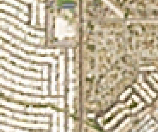
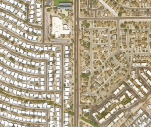
NIMBO HD Basemaps are the high-resolution (2.5 m) version of global NIMBO satellite mosaics. They are generated every month using advanced deep-learning models that enhance standard NIMBO (10m) basemaps made from Sentinel-2 satellite data into a crisp, visually coherent, and highly detailed representation of the Earth.
Built on top of the monthly NIMBO (10 m) basemaps, NIMBO HD preserves the same strengths (global cloud-free coverage, natural color balance, radiometric stability) while adding a new level of visual richness that approximates very high-resolution imagery.
The result are global 2.5 m satellite basemaps, refreshed monthly, optimized for monitoring, mapping, environmental dashboards, and AI workflows that benefit from high spatial detail.
Technical Specifications
Section titled “Technical Specifications”| Feature | Details |
|---|---|
| Service URL | https://prod-data.nimbo.earth/mapcache/tms/1.0.0/{year}_{month}_5@kermap/{z}/{x}/{y}.png?kermap_token=[YOUR_TOKEN] |
| Format | PNG (RGB) |
| Zoom Levels | 0 to 18 |
| Coordinate System | Web Mercator (EPSG:3857) |
| Coverage | Global Land (85°N to 85°S) |
| Tile Size | 256x256 px |
Parameters:
year: Four-digit year (e.g.2024)month: Month number (1–12)5is the NIMBO HD identifierz,x,y: Standard XYZ tile coordinates.kermap_token: Your API authentication token.
Monthly updates and data freshness
Section titled “Monthly updates and data freshness”Each month, NIMBO processes the global NIMBO 10m satellite mosaics and generates a new HD version using dedicated super-resolution models.
The HD product follows the same rhythm:
- Mosaic period: Calendar month (e.g., September 2025)
- Delivery: Around the 15th of the following month
- Update frequency: Monthly, worldwide
Because HD mosaics inherit the same cloud-free synthesis and radiometric consistency as the 10m basemap, users can rely on a fresh, clean, and realistic global satellite image every month, but at 2.5 m resolution.
This monthly cadence makes NIMBO HD one of the fastest-updated high-definition global mosaics available today.
How the HD enhancement works
Section titled “How the HD enhancement works”NIMBO HD is built using proprietary deep-learning models trained on millions of paired examples of high-resolution (1–2 m) and medium-resolution (10 m) satellite imagery. These models are specifically optimized for Sentinel-2 characteristics, colorimetry, and noise profile.
The model architecture is designed to:
- Reconstruct fine-scale patterns such as small roads, field boundaries, river edges, or rooftop structures
- Preserve spectral and radiometric fidelity, ensuring natural colors consistent with Sentinel-2
- Avoid hallucinations — the model enhances existing structures without inventing unrealistic objects
- Maintain textural coherence over large agricultural or natural areas
- Reduce noise and compression artefacts inherited from raw 10 m data
Unlike classical interpolation methods (like bicubic or Lanczos), the HD model learns real spatial structures from high-resolution training examples. This makes the result visually close to native high-resolution imagery, while remaining globally consistent and analytically safe.
The HD reconstruction is always derived from a single source: the latest monthly NIMBO 10 m mosaic, ensuring perfect temporal consistency across resolutions.
Confidence layer
Section titled “Confidence layer”Each NIMBO HD mosaic is delivered with a Confidence Layer, indicating how reliable the reconstructed 2.5 m detail is at each pixel.
| Value range | Meaning |
|---|---|
| 0.8 – 1.0 | High confidence — strong structural consistency |
| 0.5 – 0.8 | Medium confidence — acceptable enhancement |
| < 0.5 | Low confidence — uncertain fine details |
This layer is derived from the internal predictive uncertainty of the HD model and can be used to:
- Mask unreliable areas
- Weight pixel importance in AI models
- Improve change detection stability
- Filter uncertain structures in analytical workflows
It acts like a transparency or quality map, making the product more trustworthy for professional use.
NIMBO HD Coverage
Section titled “NIMBO HD Coverage”NIMBO HD is not produced over the Earth’s whole landmass as the 10 m mosaics are. Instead, the HD pipeline focuses on the areas where high-resolution detail truly matters.
Every month, approximately 75% of the world’s habitable land is processed at 2.5 m resolution.
This includes:
- almost all urban areas,
- agricultural and rural landscapes,
- major infrastructures and transport corridors,
- forests, wetlands, and coastal zones where people live or operate.
The areas excluded are primarily large uninhabited or lower-interest regions, such as:
- the Sahara, Arabian, or Australian deserts,
- the Gobi and other major drylands,
- high-latitude or mountainous regions with extremely low population density.
These exclusions help maintain an optimal balance between global scale, monthly refresh, and high-resolution processing capacity.
Add your own AOI — at no extra cost
Section titled “Add your own AOI — at no extra cost”If you need HD coverage outside the default processing footprint, we can add your Area of Interest (AOI) to our routine production at no extra cost.
Just contact us via the NIMBO request form, and we will be happy to:
- evaluate your AOI,
- integrate it into the next production cycle,
- confirm delivery timing directly with you.
Your needs shape NIMBO — and we gladly adapt the HD footprint to support your projects.
Historical Availability
Section titled “Historical Availability”NIMBO HD is a relatively new product within the NIMBO ecosystem.
The global HD mosaics are currently available starting from April 2025.
| Period | Availability |
|---|---|
| Before April 2025 | Not available by default |
| April 2025 – June 2025 | Version v1 (first HD model) |
| July 2025 – Present | Version v55-80 (improved model, better texture & fidelity) |
If you require older satellite imagery, or wish to extend the historical archive for specific areas, we can generate custom HD retrospectives upon request.
Simply reach out through the contact form, and we will provide a tailored assessment and delivery options.
Evolving Product & Change Log
Section titled “Evolving Product & Change Log”NIMBO HD is an active, evolving product.
Our models and processing pipelines continue to improve, and this means HD satellite mosaics may change in quality, sharpness, or texture over time as better versions are released.
To ensure full transparency, NIMBO HD includes a versioned history of model improvements:
Change Log
Section titled “Change Log”| Version | Period | Description |
|---|---|---|
| v1 | April → June 2025 | First-generation HD model. Strong enhancement, coherent color reproduction, but smoother textures. |
| v55-80 | July 2025 → Present | Improved model with sharper textures, better structural reconstruction, and stronger perceptual consistency. |
Future versions will continue to enhance spatial accuracy, detail sharpness, and radiometric consistency.
Whenever a new HD model is deployed, we will document the changes so that users can track the evolution of the product and understand any differences between monthly mosaics.